









KNOWLEDGE / EXPERIENCE / IMPACT
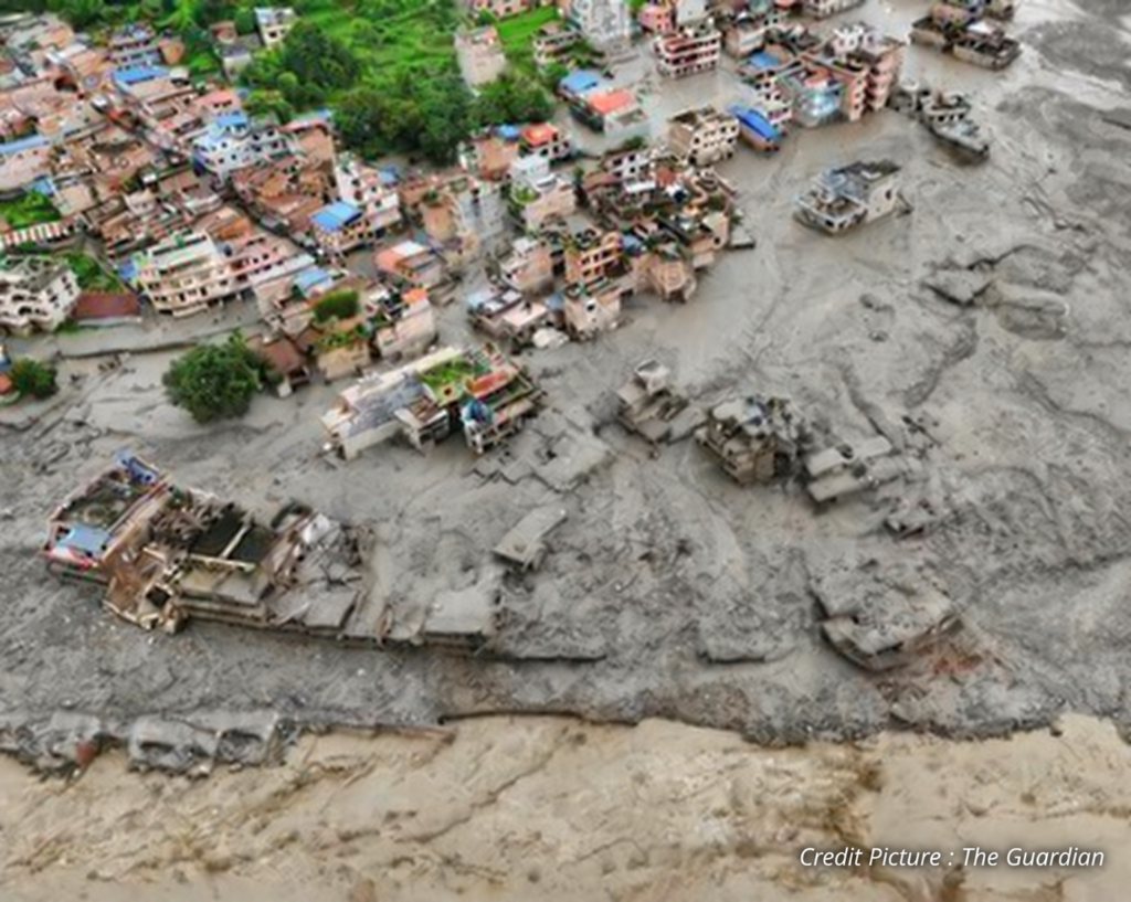
The mountains can change in a matter of minutes. In the early morning of 26th August 2026, a sudden failure on the Langtang-Lirung mountain in Rasuwa, Nepal triggered an ice-rock avalanche that moved into the Lhende Khola and then into the Bhote Koshi-Trishuli river system. Water, ice, rock and sediments had travelled rapidly downstream, damaging local communities and critical infrastructure across the border in Tibet and Nepal. International Centre for Integrated Mountain Development (ICIMOD) later identified the event as an ice-rock avalanche and highlighted it as an example of how a hazard originating high in the mountains can quickly turn into a major downstream flood.
The event was widely described as a “Himalayan tsunami” because of the sudden and destructive nature of the flood. Scientifically, however, it is important to distinguish it from a glacial lake outburst flood (GLOF). A GLOF occurs when water stored in a glacial lake is suddenly released while the Rasuwa event began with the collapse of rock and ice from a high mountain slope. This distinction matters because it shows that early warning systems need to look beyond known glacial lakes and river levels and consider the wider mountain environment.
Nepal has already made considerable progress in early warning. The Department of Hydrology and Meteorology operates hydrological and meteorological monitoring systems, while community-based warning mechanisms and real-time flood information help communities prepare for rising river levels. Nepal also has experience with systems specifically designed for glacial hazards. For example at Imja Lake water levels were lowered to reduce GLOF risk and automated warning systems were installed along the downstream corridor. United Nations Development Programme (UNDP) reports that hydro-meteorological and GLOF sensors, automated sirens and community-based early warning systems are already operating in different parts of the country.
Glacial lakes remain an important concern. As glaciers retreat and mountain environments change, meltwater can accumulate behind natural dams made of ice, rock and sediment. If these dams fail large volumes of water can move downstream very quickly. Nepal has identified potentially dangerous glacial lakes and is expanding monitoring and risk-reduction measures through programmes such as the GLOF Sanjibani Project. The project combines glacier and lake monitoring, hydrological and meteorological observations, early warning systems and physical risk-reduction measures at priority lakes.
However, the Rasuwa disaster shows why monitoring glacial lakes alone is not enough. Landslides, rockfalls, avalanches, glacier collapses and unstable slopes can also generate sudden floods or debris flows. These hazards can occur in combination, creating what are known as cascading hazards. A collapse high on a mountain can enter a river, block it temporarily, release a sudden surge and carry large quantities of sediment and boulders downstream. In the Rasuwa event, water levels on the Trishuli reportedly rose by as much as nine meters within 30 minutes, demonstrating how little time may be available once such an event begins.
Several technologies could help improve detection. Satellite imagery can monitor glaciers, glacial lakes, unstable slopes and changes in river channels across areas that are difficult to access on the ground. Ground-based sensors, cameras, river gauges, weather stations and other monitoring equipment can provide more frequent information at specific high-risk locations. Seismic information can also contribute to understanding sudden changes in mountain terrain. The challenge is not necessarily the absence of these technologies, but how quickly information from them can be combined and turned into a warning that reaches people.
This was one of the important lessons identified after the Rasuwa-Gyirong disaster. ICIMOD’s September 2026 regional workshop resulted in the “Kathmandu 10 Action Points”, which call for early warning triggers that account for sudden-onset hazards, satellite-based identification of multi-hazard hotspots, impact-based forecasting and faster movement from raw data to decision-ready information. The recommendations also call for stronger cross-border cooperation and a shared data system to reduce institutional gaps.
For Nepal, a stronger system could therefore combine satellite monitoring with ground-based observations in identified high-risk mountain hotspots. If satellite data showed significant changes around a glacier or unstable slope, more detailed monitoring could be activated in that area. A sudden movement detected by ground instruments could then be checked against river and weather observations. If an event occurred, downstream water-level sensors could provide another layer of confirmation while forecasting tools estimate which settlements and infrastructure may be affected.
The warning itself also needs to become more useful to the people receiving it. Rather than only communicating that a river has crossed a particular level, an impact-based warning could indicate which communities, roads or bridges may be affected and what action should be taken. This would connect monitoring directly with preparedness and evacuation. Throughout this community participation remains essential because even the most advanced technology cannot protect people if warnings do not reach them or if there is no clear plan for what to do afterwards.
The cross-border nature of the disaster makes cooperation particularly important. Mountain hazards and rivers do not stop at national boundaries and information from one side of the border may be critical for communities on the other. ICIMOD has specifically highlighted the need for stronger regional collaboration so that countries can move beyond simply sharing data and instead exchange information that can support immediate decisions.
The lesson from Rasuwa is therefore not that Nepal has no early warning system. Nepal already has monitoring networks, flood forecasting, GLOF warning systems and community-based mechanisms. The bigger challenge is extending these systems to hazards that begin higher in the mountains and develop faster than conventional flood warnings can capture. A more connected, multi-hazard system that link satellites, ground sensors, river monitoring, scientific analysis, cross-border information and community action could provide those additional minutes that matter most during a sudden mountain disaster.
As the Himalayan environment continues to change, early warning will need to change with it. The goal is not to predict every landslide or glacier collapse with certainty. It is to recognize dangerous changes earlier, understand how they could cascade downstream and make sure that the information reaches the people who need it before the hazard does.
References